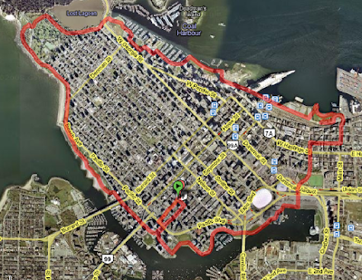
This evening I did a circuit around downtown Vancouver on skates: 13km round trip from our place; it took me 75 minutes. The route is designed to avoid hills as much as possible: the only steep hill I couldn't avoid was the Main St. bridge.
I used the Google
Distance Measurement Tool to create this
map, but there was no way to save it.

Street-by-street summary
Seymour St, Helmcken St. (
future greenway!), Richards St, Beach Crescent,
Seawall,
Carrall St Greenway (beeyoutious!), E. Cordova St. (baaad neighbourhood), Main St (gorgeous view from the bridge, which has a steep decline for inline skates), Waterfront Rd. (which goes under the
SeaBus bridge,
Canada Place and
annex), dive through a parking garage to get to the
Coal Harbour Seawalk. At this point you can stay on the seawall, although I use the side streets (Cardero St, Bayshore Dr, Denman St.) because the paving stones are a little too bumpy for my taste. This takes you to
Stanley Park. You can go around the Stanley Park Seawall, which is beautiful (another 9km), but I chose to take the bike trail through the Georgia St pedestrian tunnel and along the shore of Lost Lagoon, and follow the path though the bike tunnel under Stanley Park Dr. to Second Beach. From Second Beach the bike path is very narrow and shared with pedestrians, so look out... but continue along the (beautiful) seawall until the end of Sunset Beach where you reach the
Vancouver Aquatic Centre. From there, I recommend taking Beach Ave back to Beach Crescent – which is a full loop.


4 comments:
Sounds like fun.
Was it 75 minutes for the circuit, or 75 minutes just to get up that hill?
Hmm, yes. The hill only takes a few seconds to go down, although it could have taken a few minutes off my life.
That was great hon! Keep it up!
;-)
When I'm feeling a bit more confident on my skates (and when I can find some pads that fit) you'll have to take me with you.
Post a Comment